
Despite some of the obvious changes in climate, unanimously being documented by scientists across the globe, the issue of climate change has yet to become a truly global concern. This is primarily why the New York Film Academy has recently set forth on a new venture, stemming from its S.T.E.A.M. initiative headed up by Rajiv Uttamchandani, Director of S.T.E.A.M. Education Initiatives at NYFA.
Harnessing the power of visual storytelling, NYFA placed forward a brave new effort in increasing awareness of the effects of climate change on our environment. Students experience first hand the reward of capturing images of the Earth at increasing altitudes with state-of-the-art, ultra high-resolution cameras. From this, they are able to appreciate the beauty of our planet and its sensitivity in a way that can never be obtained in a classroom.
“At the New York Film Academy, we place emphasis on giving our students the best possible educational experience possible – by providing students with the hands-on opportunity to physically apply what they learn in class,” says Rajiv Uttamchandani. “They use the scientific method to solve problems and come up with solutions.”
Recently, visual artists from the New York Film Academy teamed with physicists from California State University, Northridge, to investigate the effects of global warming on the health of Southern California’s natural vegetation.
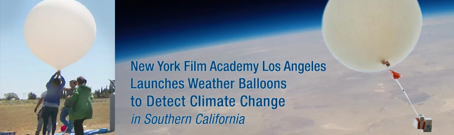
In collaboration with Cal State Northridge, BFA Acting students launched two weather balloons from Tehachapi, California that were able to capture these vast images of vegetation. The balloons also carried with them special instruments to measure temperature, pressure, humidity, and wind direction. Reaching altitudes of approximately 90,000 feet, the balloons traveled a linear distance of 35 miles, eventually landing in the Mojave Desert.
Through the launch, students were able to complete two missions:
Mission (1) – investigate vegetation in southern California, compare with past images taken from satellites as part of the US Geological Survey, which contains satellite images of locations throughout the U.S. and investigate any visible change in pattern of growth of natural vegetation due to warming climates.
Mission (2) – use IR images and compare with visible light images to obtain a relative index of moisture content in soil. Compare with past data.
See for yourself these incredible images and watch the experiment played out in this wonderful piece put together by the NYFA Media Content Department.
Credits:
Creative Director and Producer: David Nelson
Director: Ty Greene
Editor: Vinny Sisson